
Greenstone-Caples Track, Glenorchy
Glenorchy is a small settlement, situated in Otago region, at South Island in New Zealand. It lies on the northern side of Lake Wakatipu and is surrounded by Richardson and Humboltd Ranges.
Home > MOUNTAIN SPORTS > Backpacking / Trekking > Clavey River, Sonora
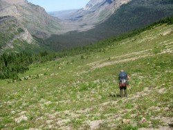
Trails are spread everywhere across the mountains. There is something for everyone in the Sonora Pass region, as there are all kind of trails, easy, intermediate and high elevation and also long day adventures. One of the best trails to go backpacking is Hull Creek to Clavey River.
If you are looking for solidarity and quiet amid the beautiful, rugged scenery of the mountains, you should definitely follow that trail. It is a 9 mi/14.5 km trail, following the path of the Old West Side Lumber Company’s railroad line. Trails on the railroad line guarantee an easy grade.
This trail, however, is kind of tricky to reach and difficult to follow. In order to pull it through, you must be adventurous enough, have very good, directional skills and always carry a map and a compass or GPS. You can camp anywhere around the trail.
Glenorchy is a small settlement, situated in Otago region, at South Island in New Zealand. It lies on the northern side of Lake Wakatipu and is surrounded by Richardson and Humboltd Ranges.
Bear Valley is a ski area located near Angels Camp, on highway 4, between Lake Tahoe and Yosemite, approximately 3 hours southeast of Sacramento, California, USA.
Sonora Pass is located near Pinecrest, Tuolumne County, California, USA. It is off of Highway about 60 mi/96.5 km east of Sonora.
Bear Valley is a ski area located near Angels Camp, on highway 4, between Lake Tahoe and Yosemite, approximately 3 hours southeast of Sacramento, California, USA.
Metsovo, one of Greece's best known resorts, boasts some of the most spectacular scenery in the Balkan Peninsula, offering a backdrop of forested hills, rivers and springs surrounded by a national park and protected areas.
Sonora Pass is located near Pinecrest, Tuolumne County, California, USA. It is off of Highway about 60 mi/96.5 km east of Sonora.
Mount Shasta is located in northern California, east of Interstate 5 along SR89, between Mount Shasta city and McCloud city, California, USA.
Squaw Valley Ski Resort is located in Olympic Valley, California, USA. It is one of the largest ski areas in the US after Heavenly and was the site of the 1960 Winter Olympics.
Sonora Pass is located near Pinecrest, Tuolumne County, California, USA. It is off of Highway about 60 mi/96.5 km east of Sonora.
Lake Shasta Caverns is located in northern California, east of Interstate 5 along SR89, between Mount Shasta city and McCloud city, California, USA.
Bear Valley is a ski area located near Angels Camp, on highway 4, between Lake Tahoe and Yosemite, approximately 3 hrs southeast of Sacramento, California, USA.
Mammoth Lakes is located near Mammoth Mountain, in California’s eastern Sierra about 100 mi/161 km south of Nevada State Line, 9 mi/14.5 km northwest of Mount Morrison, at an elevation of 7880 ft/2402 m, Mono County, California, USA.
Bear Valley is a ski area located near Angels Camp, on highway 4, between Lake Tahoe and Yosemite, approximately 3 hours southeast of Sacramento, California, USA.