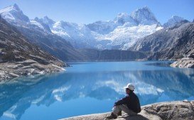
Pacific Crest Trail, Angels Camp
Bear Valley is a ski area located near Angels Camp, on highway 4, between Lake Tahoe and Yosemite, approximately 3 hours southeast of Sacramento, California, USA.
Home > MOUNTAIN SPORTS > Backpacking / Trekking > Clavey River, Sonora
Trails are spread everywhere across the mountains. There is something for everyone in the Sonora Pass region, as there are all kind of trails, easy, intermediate and high elevation and also long day adventures. One of the best trails to go backpacking is Hull Creek to Clavey River.
If you are looking for solidarity and quiet amid the beautiful, rugged scenery of the mountains, you should definitely follow that trail. It is a 9 mi/14.5 km trail, following the path of the Old West Side Lumber Company’s railroad line. Trails on the railroad line guarantee an easy grade.
This trail, however, is kind of tricky to reach and difficult to follow. In order to pull it through, you must be adventurous enough, have very good, directional skills and always carry a map and a compass or GPS. You can camp anywhere around the trail.
Bear Valley is a ski area located near Angels Camp, on highway 4, between Lake Tahoe and Yosemite, approximately 3 hours southeast of Sacramento, California, USA.
Ama Dablam Mountain is a mountain situated in the Himalaya range of eastern Nepal. Its name means Mother’s necklace and it is the third most popular Himalayan summit for permitted expeditions.
Sonora Pass is located near Pinecrest, Tuolumne County, California, USA. It is off of Highway about 60 mi/96.5 km east of Sonora.
Bali is a province in Indonesia with a few neighboring islands including the Isle of Bali. The island of Bali lies at about 8 degrees/ 0.13 radians on the south of equator and at 3.2 km/1.9 mi from Java. It is surrounded by coral reefs with white sand beaches on the south and black sand beaches on the north and the west of the island.
Sonora Pass is located near Pinecrest, Tuolumne County, California, USA. It is off of Highway about 60 mi/96.5 km east of Sonora.
Bear Valley is a ski area located near Angels Camp, on highway 4, between Lake Tahoe and Yosemite, approximately 3 hours southeast of Sacramento, California, USA.
Sonora Pass is located near Pinecrest, Tuolumne County, California, USA. It is off of Highway about 60 mi/96.5 km east of Sonora.
Squaw Valley Ski Resort is located in Olympic Valley, California, USA. It is one of the largest ski areas in the US after Heavenly and was the site of the 1960 Winter Olympics.
Soda Springs ski resort is located near Soda Springs, Nevada County, California, USA. Soda Springs ski resort is just off of Highway 80, near the Donner Summit.
Mount Shasta is located in northern California, east of Interstate 5 along SR89, between Mount Shasta city and McCloud city, California, USA.
Sonora Pass is located near Pinecrest, Tuolumne County, California, USA. It is off of Highway about 60 mi/96.5 km east of Sonora.
Bear Valley is a ski area located near Angels Camp, on highway 4, between Lake Tahoe and Yosemite, approximately 3 hours southeast of Sacramento, California, USA.
