Long Valley, Sonora
Sonora Pass is located near Pinecrest, Tuolumne County, California, USA. It is off of Highway about 60 mi/96.5 km east of Sonora.
Home > OTHER SPORTS > Horseback Riding > Waipio Valley, Honokaa
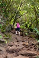
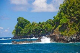
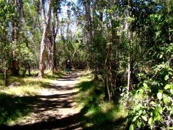
After that, the town became a touristic destination with the beautiful Waipio Valley and Kalopa Native Forest State. Waipio Valley is one mile across and about 5 mi/8 km deep, surrounded by mountains with impressive waterfalls and green fields.
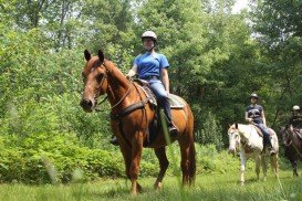
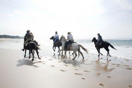
Waipio Valley horseback riding tour starts at the end of Honokaa Rd, where you come across a rocky and steep road leading down to the valley floor and ends at a stream. This road is only accessible with a 4wd but if you don’t have one, you can walk down and start enjoying the view. The riding tours are guided from experienced riders that will lead you on a journey through the history and legends of Waipio Valley.
Nature is overwhelming and the horse trails lead you deep inside the jungle, along the hillside and through streams and rivers. You don’t have to be an experienced horse back rider to take this journey. Nonetheless, kids under eight years old are not allowed to join any team, due to unpredictable weather and terrain conditions.
Riders should wear light rain jackets because rain showers are frequent. For accommodation you can either stay in Hilo town or choose a hotel in Honokaa Town with a great view of Waipio Valley.
Sonora Pass is located near Pinecrest, Tuolumne County, California, USA. It is off of Highway about 60 mi/96.5 km east of Sonora.
Mammoth Lakes is located near Mammoth Mountain, in California’s eastern Sierra about 100 mi/161 km south of Nevada State Line, 9 mi/14.5 km northwest of Mount Morrison, at an elevation of 7880 ft/2402 m, Mono County, California, USA.
Chyulu Hills borders the Amboseli and Tsavo East plains border. The hills rise to an approximate of 2200 m/7217 ft and stretching at 150 km/93 mi long of mountain range, giving in an impressive distant view of Kilimanjaro mountain. These hills are home to acacia woodlands while a series of volcanic craters are covered in dense forests. Chyulu hills also hosts the deepest known lava cave tube in the world.
North West is a province in the northern part of South Africa, on the Botswana border and fringed by Kalahari desert to the west, Gauteng province to the east and Free State to the South. Home to the Sun City, it attracts both locals and tourists all year round and has a great deal to offer. It is peaceful and offers a sunny climate all year through, making for a most rewarding holiday experience.
False Bay is a body of water characterized by Cape Hangklip and Cape Peninsula, located in the southwest of South Africa. The bay is 30 km/18.7 mi wide, offering a Mediterranean climate with warm, dry summers and wet damp winters. The east and western shores of the bay are rocky and mountainous with visible peaks rising from the waters, while the northern side comprises a long, curving beach.
The Elephant coast is located on the eastern seaboard of South Africa. It stretches along the Indian Ocean in the east, it borders with Mozambique in the north while the south-west lies on the Zululand. Extending inland across the Lubombo mountains and the famous Hluhluwe-Imfolozi Game Reserve, which is the oldest in Africa and home to the big 5.
Honokaa town is located in the Hamakua Coast, at 40 mi/64 km in the north of Hilo. The area is a historic district of Big Island in Hawaii because the town's economy was once based on sugar production from the Hamakua Sugar Company, until 1994.
Chocks beach is located in Hilo, in Hawaii, which is the most populated city of the island. Hilo is an old fashioned bay front town, with tropical rain forest climate all year long, and home of the Tsunami Museum, dedicated to the understanding of the 1946 Pacific Tsunami.
Kulani is a mountain located South of Hilo district, Hawaii. The nearest places to Kulani forest are Na Lua Mahoe, Pu'ulala'au natural area reserve and Upper Ola'a Forest reserve.
Volcano National park is located at 30 mi/48 km in the southwest of Hilo Town in Hawaii. The park was established in 1916 and is a combination of unique ecosystems and diverse environments that range from the sea to the summit of the world's biggest volcano, Mauna Loa, as well as Kilauea witch is the world's most active volcano.
Volcano National park is located at 30 mi/48 km in the southwest of Hilo Town in Hawaii. The park was established in 1916 and is a combination of unique ecosystems and diverse environments that range from the sea to the summit of the world's biggest volcano, Mauna Loa, as well as Kilauea which is the world's most active volcano.
Tombstones beach is located between Paukaa and Wainaku Village Hawaii, at about seven minutes drive from Hilo, which is the most populated city on the island.
Mauna Kea is one of the five active volcanoes on the island of Hawaii, at 35 mi / 56 km in the west of Hilo Town while its peak is the highest point in the state, standing at 13803 ft / 4207 m above the sea level.
Bayfront beach is located in Hilo, Hawaii, which is the most populated city on the island. Hilo is an old fashioned bay front town, with tropical rain forest climate all year long and home of the Tsunami Museum, dedicated to the understanding of the 1946 Pacific Tsunami.
