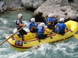
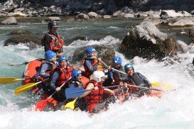
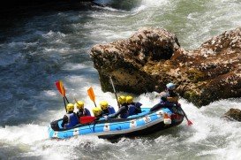
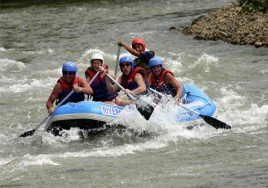
Rafting in Padas River, Kota Kinabalu,
Sabah Malaysia
Distance :
23km/14.3mi
Rapid Grade :
Class III-IV
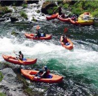
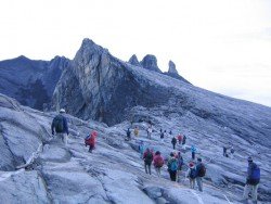
Famous due to its proximity with tropical islands, lush forests and Mount Kinabalu, Kota Kinabalu is the capital of the state of Sabah located in Borneo. It is located on the west coast of Sabah within the West coast Division. Formerly known as Jesselton, it enjoys a tropical rainforest climate and lies by the coast, overlooking at the South China Sea and bordered by the Crocker range which is home to Mount Kinabalu.
Padas River is located at the most interior part of south-western part of Kota Kinabalu and can only be accessed by train. The Padas river flows through the amazing Padas Gorge and white water rafting the Padas promises a thrilling and adrenaline rush for both the novice and expert paddler. The rapids’ sweet names like “scoobydoo” “merry-go-round” might fool you but they sure will give you the chills and test your paddling skills to the maximum!!
The paddling covers a distance of 23 km/14.3 mi long with 7 exhilarating rapids graded between class III-IV. The rapids starting point is at a traditional village, called Pangi which is home to the local Murat tribe who were previously head hunters!! Safety is at top notch as there are guides who take you through this thrilling adventure. Minimum age requirement here is 12 years old with some level of fitness and advance booking is necessary.
Wenatchee is the largest city of Chelan County, located in North Central Washington and lies on the west side of the Columbia River. The city is also known as the Apple Capital of the world, due to the valley's many apple cultivations.
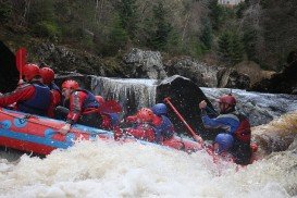
Findhorn river will give you a perfect combination of extreme white water rafting, as it is one of the most famous destinations, due to its massive drop gradient of 152 m/500 ft.
Victoria Falls, in Zambia, is the borderline between the Upper and the Middle Zambezi River. Within few kilometers below, the river flows through the Batoka Gorge, where the most challenging whitewater rafting can be performed.
Saint-Crepin is situated in the Hautes-Alpes department (Provence-Alpes, Cote d'Azur region) in the south-east of France at 45 km/27 mi from Gap, the departmental capital. The village is located near the Durance River, ideal spot for whitewater kayaking or canoeing.
Saint Martin du Puy is a small rural community, gathering eight villages in Burgundy of central France. The village of ''Plainfas'' is the most populated one and it is located near a beautiful lake, called Lac du Caumecon.
North Umpqua River is located near Roseburg in southwestern Oregon. It is a tributary of the Umpqua River and it drains a scenic area of the Cascade Range, flowing through steep canyons and surrounded by big Douglas-fir forests.
Famous due to its proximity with tropical islands, lush forests and Mount Kinabalu, Kota Kinabalu is the capital of the state of Sabah located in Borneo. It is located on the west coast of Sabah within the West coast Division. Formerly known as Jesselton, it enjoys a tropical rainforest climate and lies by the coast, overlooking at the South China Sea and bordered by the Crocker range which is home to Mount Kinabalu.
Famous for its proximity with the tropical islands, lush forests and Mount Kinabalu, Kota Kinabalu is the capital of the state of Sabah located in Borneo. It is located on the west coast of Sabah within the West coast Division. Formerly known as Jesselton, it enjoys a tropical rainforest climate and lies by the coast overlooking the South China Sea and bordered by the Crocker range which is home to Mount Kinabalu.
Famous for its proximity with the tropical islands, lush forests and Mount Kinabalu, Kota Kinabalu is the capital of the state of Sabah located in Borneo. It is located on the west coast of Sabah within the West coast Division. Formerly known as Jesselton, it enjoys a tropical rainforest climate and lies by the coast overlooking the South China Sea and bordered by the Crocker range which is home to Mount Kinabalu.
Famous due to its proximity with tropical islands, lush forests and Mount Kinabalu, Kota Kinabalu is the capital of the state of Sabah located in Borneo. It is located on the west coast of Sabah within the West coast Division. Formerly known as Jesselton, it enjoys a tropical rainforest climate and lies by the coast, overlooking the South China Sea and bordered by the Crocker range which is home to Mount Kinabalu.
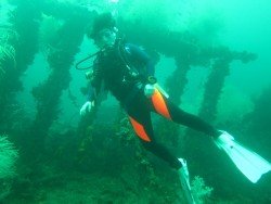
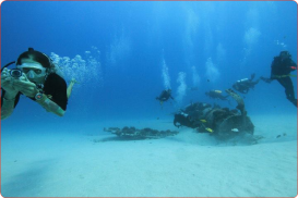
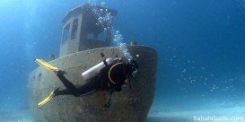
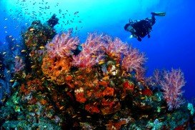
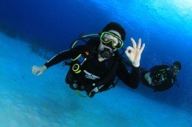
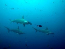
Pulau Tiga is located at 48 km/29.9 mi in the south of Kota Kinabalu and became well known due to the "Survivor" series, hosting the setting of "Survivor Borneo", the first American season of the show. Scuba diving in Pulau Tiga is open to all levels of divers and is a prime location for macro lovers and underwater photography. The spot is believed to have been formed by the eruption of several mud volcanoes and is at 100 m/328 ft above sea level.
Famous for its proximity with tropical islands, lush forests and Mount Kinabalu, Kota Kinabalu is the capital of the state of Sabah located in Borneo. It is located on the west coast of Sabah within the West coast Division. Formerly known as Jesselton, it enjoys a tropical rainforest climate and lies by the coast, overlooking at the South China Sea and bordered by the Crocker range which is home to Mount Kinabalu.
Pulau Tiga is located at 48 km/30 mi in the south of Kota Kinabalu and became well known due to the "Survivor" series, hosting the setting of "Survivor Borneo", the first American season of the show. Scuba diving in Pulau Tiga is open to all levels of divers and is a prime location for macro lovers and underwater photography. The spot is believed to have been formed by the eruption of several mud volcanoes and is at 100 m/328 ft above sea level.
Pulau Tiga is located at 48 km/30 mi in the south of Kota Kinabalu and became well known due to the "Survivor" series, hosting the setting of "Survivor Borneo", the first American season of the show. Scuba diving in Pulau Tiga is open to all levels of divers and is a prime location for macro lovers and underwater photography. The spot is believed to have been formed by the eruption of several mud volcanoes and is at 100 m/328 ft above sea level.