Scuba Diving in Usukan Bay, Kota Kinabalu,
Sabah Malaysia
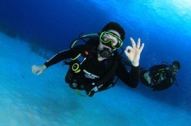
Dive Depths:
26-40m/85-131ft
Dive Type :
Wreck Dive
Famous due to its proximity with tropical islands, lush forests and Mount Kinabalu, Kota Kinabalu is the capital of the state of Sabah located in Borneo. It is located on the west coast of Sabah within the West coast Division. Formerly known as Jesselton, it enjoys a tropical rainforest climate and lies by the coast, overlooking the South China Sea and bordered by the Crocker range which is home to Mount Kinabalu.
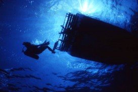
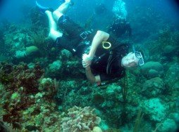
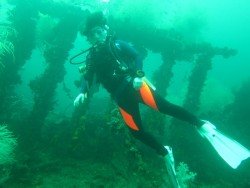
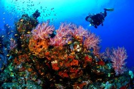
Usukan Bay offers a quality wreck diving experience. The bay comprises of 3 World War II Japanese wrecks which were all sunk on the same day in October 14th, 1944. These wrecks brought about 3 awesome wreck dive spots namely the “Usukan Wreck”, “The Rice-Bowl Wreck” and the “Upside-down Wreck”. Diving at these sites make a memorable experience and accommodates the advanced open water and technical diver with minimum qualifications and all dives are no-decompression.
All these wreck dives are located at 26-40 m/85-131 ft in depth below the sea level and have small to medium currents. This constitutes one more reason why experienced divers can attempt scuba diving here. The wrecks are characterized by both stunning hard and soft corals with abundant marine life. The minimum pax is 4 per dive and divers are advised to use Nitrox for underwater time extension.
Mombasa Marine Park & Reserve is located along the east coast of Kenya. The marine park covers an area of 6 mi/10 km (around 2,500 ac/10.12 km²) and the reserve a massive area of 124 mi/200 km square (around 49,400 ac/199.91 km²). Since it is located close to most of all the touristic areas, its beaches are one of the most visited and a great deal of activities take place at the same time.
Isla Mugeres is an amazing island in the Caribbean Sea. It is located approximately 13 km / 8 mi off the Yucatan Peninsula. The island is 7 km / 4 mi long, 650 m / 2130 ft wide and it is part of the Isla Mujeres Municipality in the state of Quintana Roo, Mexico.
Lake Garda with its 346 km / 214 mi width and 145 km / 90 mi long of shoreline, is the largest lake in Italy, offering a wide range of scuba-diving areas. The deepest part of the lake is 28 m / 921 ft below the sea level. Exploring the lake-bed will be astonished by its hidden treasures and the mysterious wrecks.
South Head is the southern headland of the entrance to Sydney Harbor, at the north of the suburb of Watsons Bay. Hornby Lighthouse, the third oldest lighthouse in New South Wales, is located in South Head.
Whyalla is located on the western shore of upper Spencer Gulf, at 394 km/244 mi in the northwest of Adelaide, in South Australia. Dolphins and bird-life often frequent the waters, while the rocky coastline is a popular destination for scuba diving.
Famous due to its proximity with tropical islands, lush forests and Mount Kinabalu, Kota Kinabalu is the capital of the state of Sabah located in Borneo. It is located on the west coast of Sabah within the West coast Division. Formerly known as Jesselton, it enjoys a tropical rainforest climate and lies by the coast, overlooking at the South China Sea and bordered by the Crocker range which is home to Mount Kinabalu.
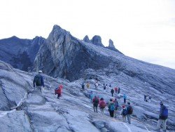
Pulau Tiga is located at 48 km/30 mi in the south of Kota Kinabalu and became well known due to the "Survivor" series, hosting the setting of "Survivor Borneo", the first American season of the show. Scuba diving in Pulau Tiga is open to all levels of divers and is a prime location for macro lovers and underwater photography. The spot is believed to have been formed by the eruption of several mud volcanoes and is at 100 m/328 ft above sea level.
Famous due to its proximity with tropical islands, lush forests and Mount Kinabalu, Kota Kinabalu is the capital of the state of Sabah located in Borneo. It is located on the west coast of Sabah within the West coast Division. Formerly known as Jesselton, it enjoys a tropical rainforest climate and lies by the coast, overlooking the South China Sea and bordered by the Crocker range which is home to Mount Kinabalu.
Famous for its proximity with the tropical islands, lush forests and Mount Kinabalu, Kota Kinabalu is the capital of the state of Sabah located in Borneo. It is located on the west coast of Sabah within the West coast Division. Formerly known as Jesselton, it enjoys a tropical rainforest climate and lies by the coast overlooking the South China Sea and bordered by the Crocker range which is home to Mount Kinabalu.
Famous for its proximity with tropical islands, lush forests and Mount Kinabalu, Kota Kinabalu is the capital of the state of Sabah located in Borneo. It is located on the west coast of Sabah within the West coast Division. Formerly known as Jesselton, it enjoys a tropical rainforest climate and lies by the coast, overlooking at the South China Sea and bordered by the Crocker range which is home to Mount Kinabalu.
Famous due to its proximity with tropical islands, lush forests and Mount Kinabalu, Kota Kinabalu is the capital of the state of Sabah located in Borneo. It is located on the west coast of Sabah within the West coast Division. Formerly known as Jesselton, it enjoys a tropical rainforest climate and lies by the coast, overlooking at the South China Sea and bordered by the Crocker range which is home to Mount Kinabalu.
Pulau Tiga is located at 48 km/29.9 mi in the south of Kota Kinabalu and became well known due to the "Survivor" series, hosting the setting of "Survivor Borneo", the first American season of the show. Scuba diving in Pulau Tiga is open to all levels of divers and is a prime location for macro lovers and underwater photography. The spot is believed to have been formed by the eruption of several mud volcanoes and is at 100 m/328 ft above sea level.
Pulau Tiga is located at 48 km/30 mi in the south of Kota Kinabalu and became well known due to the "Survivor" series, hosting the setting of "Survivor Borneo", the first American season of the show. Scuba diving in Pulau Tiga is open to all levels of divers and is a prime location for macro lovers and underwater photography. The spot is believed to have been formed by the eruption of several mud volcanoes and is at 100 m/328 ft above sea level.