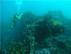
Scuba Diving in Waa Wreck, Diani Beach,
Coast Province Kenya
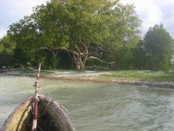
Maximum Depth:
24m/79ft
Visibility:
10-20m/33-66ft
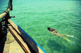
Diani Beach in Kwale County, is located at 30 km/18 mi south of Mombasa town, at 45 km/27 mi away from Mombasa International Aiport and 5 km/3 mi from the Ukunda airstrip. The beach stretches at about 25 km/15 mi long, with a stunning coral reef and huge marine life. The pearly white sand blends into warm blue waters. making it a perfect spot for beach holiday!!
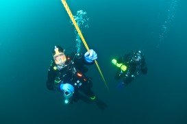
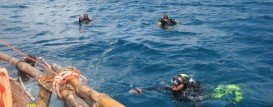
The HMS Hildasay sunk in June 1945 and it now lies down upside down in the sand at 22 m/72 ft. The wreck itself is not an interesting one, although the hull is completely covered in coral encrusting sponge and sea whips. It is a 25 minutes boat entry site and attracts a great deal of interesting fish.
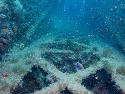
Waa Wreck accommodates both the novice and expert diver with a maximum diving depth at 24 m/79 ft and visibility stands between 10-20 m/33-66 ft. Reef sharks are a common encounter. There is a reef nearby which is perfect for the novice diver and has a number of small fish species.
Adelaide, the liveliest city in Australia, is the capital of South Australia state. The city is situated on the Adelaide Plains and more specifically at the north side of Fleurieu Peninsula. The city is built next to Torrens River and is surrounded by the Mount Lofty Ranges and the Gulf St Vincent.
One of the most beautiful islands in the Ionian Sea with emerald waters and lush nature is Zakynthos Island. Located on the west coast of Greece and being the third largest island in the Eptanisa complex, the "Flower of the East" as the Venetians used to call it, boasts amazing white sandy beaches, unique natural beauty and is also the prime nesting area for the endangered Caretta caretta sea turtles.
Mombasa Marine Park & Reserve is located along the east coast of Kenya. The marine park covers an area of 6 mi/10 km (around 2500 ac/10 km²) and the reserve a massive area of 124 mi/200 km (around 49400 ac/200 km²). Since it is located close to most of all the touristic areas, its beaches are one of the most visited and a great deal of activities take place at the same time.
Althorpe Island is located opposite the Innes National Park, in Yorke Peninsula. The spot is an tiny island, studded with dive sites walls of over 65 ft/20 m, three wrecks and seal colonies to name a few. Minimum winter temperatures average around 4°C/39.2°F and the maximum can reach 40°C/140°F during summer.
MV Malabar is a wreck site on the northern headland of Long Bay, close to Maroubra beach. The MV Malabar that was named after a small ship in Java, sank on April 1931 when it came into a heavy fog. The wreck was inaccessible to divers for almost sixty years.
Lake Michigan is the second largest Great Lake by volume and the only one located entirely in the United States. The lake’s shoreline is more than 1600 mi/2575 km and the average depth is 195 ft/59.4 m. Lake Michigan and Lake Huron have the same surface elevation and are technically a single lake. They are actually connected by the Straits of Mackinac, where many ships have foundered due to heavy storms. The Straits of Mackinac Underwater Preserve, located at the northern edge of Lakes Michigan and Huron, tries to preserve Michigan’s shipwrecks for next generations. One of the shipwrecks found is Colonel Ellsworth.
Watamu Beach is located at 120 km/74 mi in the north of Mombasa and 28 km/17 mi in the south of Malindi, the nearest big town. The shoreline of this area consists of white sandy beach and offshore corals forming three bays, namely Watamu bay, Turtle bay and Blue Lagoon. The bay is protected by a coral reef almost 0.5 km/546.81 yd off the shore.
Diani Beach is a famous beach resort situated on the Indian coast of Kenya ( in eastern Africa). It is also located 30 km/ 9 mi south of Mombasa in the nearby Kwale County. Diani Beach boasts an indigenous flora. The white sandy beach incorporated with the clear turquoise waters offers a perfect choice for an amazing beach holiday.
Having earned itself the name "Maldives" of Kenya, Galu beach is situated at 5 km / 3 mi away from Diani Beach. It is calmer than the busy Diani Beach and boasts an indigenous flora. The white sandy beach incorporated with the clear turquoise waters offers a perfect choice for an amazing beach holiday.
Mombasa Marine Park & Reserve is located along the east coast of Kenya. The marine park covers an area of 6 mi/10 km (around 2,500 ac/10.12 km²) and the reserve a massive area of 124mi/200km square (around 49,400 ac/199.91 km²). Since it is located close to most of all the touristic areas, its beaches are one of the most visited and a great deal of activities take place at the same time.
Malindi Beach, an oasis of calm and beauty, is located at 110 km/68 mi from Mombasa City. It overlooks the Malindi Marine Park while the coral garden in the park provides with an amazing flora and fauna. It offers a stunning marine life with amazing weather all year through.
Watamu Beach is located at 120 km/74 mi in the north of Mombasa and 28 km/17 mi in the south of Malindi, the nearest big town. The shoreline of this area consists of white sandy beach and offshore corals forming three bays, namely Watamu bay, Turtle bay and Blue Lagoon. The bay is protected by a coral reef almost 0.5 km/546 yd off the shore.