
Eagle Meadow, Sonora
Sonora Pass is located near Pinecrest, Tuolumne County, California, USA. It is off of Highway about 60 mi/96.5 km east of Sonora.
Home > MOUNTAIN SPORTS > Extreme Hiking / Hiking > Sugar Pine Railroad, Sonora
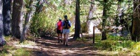
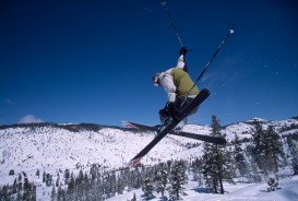
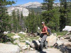
Hiking trails are spread everywhere across the mountains. There is something for everyone in the Sonora Pass region, as there are all kind of trails, easy, intermediate and high elevation and also long day adventures. One of the best trails to hike is Sugar Pine Railroad Trail.
It is a one way, 2.8 mi/4.5 km, moderate trail with an elevation gain of 500 ft/152.4 m. This trail follows the old Sugar Pine Railroad, which was used for delivering timber from remote areas of the forest to several sawmills. Nowadays it makes an excellent hiking trip, due to its gentle grade.
The beginning spot is at the Fraser Flat Road trailhead and the trail goes about 2.5 mi/4 km down to the river. Then follow it upstream on the south side of the river. It goes about 2.8 mi/4.5 km up to the connection with Old Strawberry road.
That it is another 1.5 mi/2.4 km farther on the road to finally reach Strawberry Store, where you can buy an ice cream or snack, before heading back.
Sonora Pass is located near Pinecrest, Tuolumne County, California, USA. It is off of Highway about 60 mi/96.5 km east of Sonora.
Mauna Kea is one of the five active volcanoes on the island of Hawaii, at 35 mi/56 km in the West of Hilo Town. Its peak is the highest point in the state, standing at 13803 ft/4207 m above the sea level.
Torres del Paine is located in Southern Patagonia and is one of the numerous spectacular national parks in Chile. It was created in 1959 and UNESCO has listed the location as a Biosphere Reserve since 1978. This place is a wanderland for hikers from all over the world.
El Ejido is a municipality of Almeria province, in the autonomous community of west Andalusia. It lies between the mountain range of Sierra de Gador and the Mediterranean Sea. Neighboring municipalities are Dalias and Vicar, Berja and Roquetas de Mar.
Batalegala or Bible Roch is a well-known mountain near Aranayake in Kellage District in the central province of Sri Lanka.
Pololu Valley is the Northernmost valley, forming the East coast of the Kohala Mountain after Waipio Valley. The valley goes at 420 ft/128 m downwards and it ends at a beautiful beach with black sand.
Heavenly Mountain Resort is located near the city of South Lake Tahoe, on the California-Nevada border, El Dorado County, California, USA.
Mammoth Lakes is located near Mammoth Mountain, in California’s eastern Sierra about 100 mi/161 km south of Nevada State Line, 9 mi/14.5 km northwest of Mount Morrison, at an elevation of 7880 ft/2402 m, Mono County, California, USA.
Mount Shasta is located in northern California, east of Interstate 5 along SR89, between Mount Shasta city and McCloud city, California, USA.
Squaw Valley Ski Resort is located in Olympic Valley, California, USA. It is one of the largest ski areas in the US after Heavenly and was the site of the 1960 Winter Olympics.
Sugar Bowl ski resort is a ski area in northern Placer County, near Norden, along Donner Pass of Sierra Nevada, at about 46 mi/74 km from Reno on Interstate 80, California, USA. The resort was opened on the 15th of December, 1939.
Bear Valley is a ski area located near Angels Camp, on highway 4, between Lake Tahoe and Yosemite, approximately 3 hours southeast of Sacramento, California, USA.
Bear Valley is a ski area located near Angels Camp, on highway 4 between Lake Tahoe and Yosemite approximately 3 hours southeast of Sacramento, California, USA.
Sonora Pass is located near Pinecrest, Tuolumne County, California, USA. It is off of Highway about 60 mi/96.5 km east of Sonora.