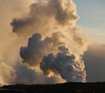
Grover Hot Springs State Park, Angels Camp
Bear Valley is a ski area located near Angels Camp, on highway 4, between Lake Tahoe and Yosemite, approximately 3 hours southeast of Sacramento, California, USA.
Home > MOUNTAIN SPORTS > Extreme Hiking / Hiking > Shadow of the Mi-Wok, Sonora
Hiking trails are spread everywhere across the mountains. There is something for everyone in the Sonora Pass region, as there are all kind of trails, easy, intermediate and high elevation and also long day adventures. One of the best trails to hike is Shadow of the Mi-Wok.
It is a 0.5 mi/0.8 km, easy trail with elevation gain of 50 ft/15.2 m. The trail starts across the road from the Summit Ranger Station at the Pinecrest Y. Park in the Ranger parking lot. Pick up a flyer from the station and then cross the road to find the beginning spot of the trail.
While wandering on that trail, you can discover and admire examples of the Mi-Wok Indian life, such as tepee-like structures built of cedar bark, grinding stones and bark shelters. The trail is not maintained during winter.
Bear Valley is a ski area located near Angels Camp, on highway 4, between Lake Tahoe and Yosemite, approximately 3 hours southeast of Sacramento, California, USA.
Mauna Loa is one of the five active volcanoes in the island of Hawaii, the largest one on earth in volume and in kilometers covered. Its peak stands at 13679 ft/4169 m above the sea level.
Mammoth Lakes is located near Mammoth Mountain, in California’s eastern Sierra about 100 mi/161 km south of Nevada State Line, 9 mi/14.5 km northwest of Mount Morrison, at an elevation of 7880 ft/2402 m, Mono County, California, USA.
Honokaa town is located in the Hamakua Coast, at 40 mi/64 km in the north of Hilo. The area is a historic district of Big Island in Hawaii because the town's economy was once based on sugar production from the Hamakua Sugar Company, until 1994.
Mount Shasta is located in northern California, east of Interstate 5 along SR89, between Mount Shasta city and McCloud city, California, USA.
Sonora Pass is located near Pinecrest, Tuolumne County, California, USA. It is off of Highway about 60 mi/96.5 km east of Sonora.
Tamarack Lodge Resort is located in Mammoth Lakes, near Mammoth Mountain, in California’s eastern Sierra about 100 mi/161 km south of Nevada State line Mono County, California, USA.
Sugar Bowl ski resort is a ski area in northern Placer County, near Norden, along Donner Pass of Sierra Nevada, at about 46 miles/74 km from Reno on Interstate 80, California, USA. The resort was opened on the 15th of December 1939.
Bear Valley is a ski area located near Angels Camp, on highway 4, between Lake Tahoe and Yosemite, approximately 3 hours southeast of Sacramento, California, USA.
Tamarack Lodge Resort is located in Mammoth Lakes, near Mammoth Mountain, in California’s eastern Sierra about 100 mi/161 km south of Nevada State line Mono County, California, USA.
Sonora Pass is located near Pinecrest, Tuolumne County, California, USA. It is off of Highway about 60 mi/96.5 km east of Sonora.
Mount Shasta is located in northern California, east of Interstate 5 along SR89, between Mount Shasta city and McCloud city, California, USA.
Don Pedro Reservoir is situated across the Tuolumne River, in the Stanislaus National Forest, Tuolumne County, California.
