Pacific Crest Trail, Angels Camp
Bear Valley is a ski area located near Angels Camp, on highway 4, between Lake Tahoe and Yosemite, approximately 3 hours southeast of Sacramento, California, USA.
Home > MOUNTAIN SPORTS > Backpacking / Trekking > Routeburn Track, Glenorchy
It is located at 44 km/27 mi from Queenstown (a breathtaking, scenic drive) and consists the gateway to Fiordland and Mount Aspiring National Parks. Glenorchy and the surrounding area was the setting for the legendary films Lord of the Rings and X-Men Origins.
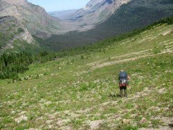
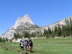
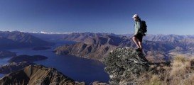
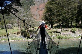
The Routeburn Track starts from Glenorchy and gets up to Te Anau. It extends for 32 km/19 mi and is one of the best trekking tracks worldwide, traversing both Fiordland and Mt Aspiring National Parks (World Heritage Area).
Grasp the unique opportunity to pass by rivers and lakes, cross beech forests, enjoy the truly breathtaking view of mountains and experience the wild nature. If you wish to complete the track, you should allow 3-4 days depending on fitness level. The Routeburn Flats and Lake Mackenzie Huts are the only two camping sites on the Track.
Note: Camping outside the designated areas is prohibited. For hut and accommodation information check with the official DOC website. Bookings are essential.
Bear Valley is a ski area located near Angels Camp, on highway 4, between Lake Tahoe and Yosemite, approximately 3 hours southeast of Sacramento, California, USA.
Sonora Pass is located near Pinecrest, Tuolumne County, California, USA. It is off of Highway about 60 mi/96.5 km east of Sonora.
Bear Valley is a ski area located near Angels Camp, on highway 4, between Lake Tahoe and Yosemite, approximately 3 hours southeast of Sacramento, California, USA.
Glenorchy is a small settlement, situated in Otago region at South Island in New Zealand. It lies on the northern side of Lake Wakatipu and is surrounded by Richardson and Humboltd Ranges.
Maasai Mara covers about 1500 km²/579.15 mi² and consists of gently rolling hills, acacia and woodland trees, watered by the Mara and Talek rivers. Landscape at the Mara is stunningly free and abundantly rich in wildlife, allowing for magnificent viewing while trekking primitive paths and trails in the middle of a pure African reality.
Queenstown is considered by many sportsmen as the capital of extreme sports and adventure activities. It is situated in Otago region, in the South Island, New Zealand.
Wanaka is a small town in Central Otago in the South Island of New Zealand, situated on the south side of Lake Wanaka.
Arrowtown is a small, former gold-mining town, situated in Otago region, in the South Island, New Zealand. It is only 20 min drive from Queenstown (connected through Shotover Gorge) and lies on the banks of Arrow River, one of the richest sources of gold in the 1860's.
Wanaka is a small town in Central Otago in the South Island of New Zealand, situated on the south side of Lake Wanaka.
Mount Sabre (2.162 m/7093 ft high) is part of the spectacular Darren Mountains, situated in the northern part of Fiordland.
Queenstown is considered by many sportsmen as the capital of extreme sports and adventure activities. It is situated in Otago region, in the South Island, New Zealand.
