Glenorchy, South Island
Glenorchy is a small settlement, situated in Otago region, in the South Island, New Zealand. It lies on the northern side of Lake Wakatipu and is surrounded by Richardson and Humboltd Ranges.
Home > MOUNTAIN SPORTS > Backpacking / Trekking > Ebbetts Pass, Angels Camp
Near Bear Valley lies Ebbetts Pass, which is perfect for backpacking. Day rides can vary from unstrained, quarter mile rides to full day excursions on strenuous mountain peaks. One of the best rides is at the Spicer Meadow Reservoir Area. This area has three different trail paths.
The first trail is Elephant Rock Lake to Rock Lake, which is a 1.8 mi/2.9 km, one way mountain trail with 800 ft/244 m elevation, gain rising. If you want to try an easier trail, go to Elephant Rock, a half mile trail each way, where the terrain is level.
The second trail is Around Utica Reservoir, which is a 6 mi/9.6 km, one way cross country trail with 100 ft/30.5 m, up and down elevation. It is not an official trail, but it is an obvious one around the lake. You can bring fishing gear and fresh water to experience camping, enjoying the surrounding beauty of the scenery.
The third trail is Spicer to Sand Flat, which is a 5.5 mi/8.8 km, one way mountain trail with drop 1000 ft/304.8 m elevation, going up. There is a bridge you can cross and hike up to Highway 4, at Big Meadow for pick up.
Glenorchy is a small settlement, situated in Otago region, in the South Island, New Zealand. It lies on the northern side of Lake Wakatipu and is surrounded by Richardson and Humboltd Ranges.
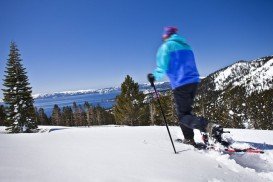
Bear Valley is a ski area located near Angels Camp, on highway 4, between Lake Tahoe and Yosemite, approximately 3 hours southeast of Sacramento, California, USA.
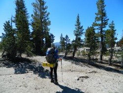
Glenorchy is a small settlement, situated in Otago region, at South Island in New Zealand. It lies on the northern side of Lake Wakatipu and is surrounded by Richardson and Humboltd Ranges.
Sonora Pass is located near Pinecrest, Tuolumne County, California, USA. It is off of Highway about 60 mi/96.5 km east of Sonora.
Mammoth Lakes is located near Mammoth Mountain, in California’s eastern Sierra about 100 mi/161 km south of Nevada State Line, 9 mi/14.5 km northwest of Mount Morrison, at an elevation of 7880 ft/2402 m, Mono County, California, USA.
The plateau of Folois nestles at the southwest foot of Mount Erymanthus, in Hleia. Its name derived from mythology and the king of the Centaurs, Follo, friend of Hercules. Folois forest, with the unrivaled natural beauty, is one of the largest oak forests in Europe.
Tamarack Lodge Resort is located in Mammoth Lakes, near Mammoth Mountain, in California’s eastern Sierra about 100 mi/161 km south of Nevada State line Mono County, California, USA.
Soda Springs ski resort is located near Soda Springs, Nevada County, California, USA. Soda Springs ski resort is just off of Highway 80, near the Donner Summit.
Northstar California is a ski resort, located near Truckee, California, USA. It is a very big ski resort, covering 3170 skiable acres/12.83 km².
Sugar Bowl ski resort is a ski area in northern Placer County, near Norden, along Donner Pass of Sierra Nevada, at about 46 miles/74 km from Reno on Interstate 80, California, USA. The resort was opened on the 15th of December 1939.
Mount Shasta is located in northern California, east of Interstate 5 along SR89, between Mount Shasta city and McCloud city, California, USA.
South Lake Tahoe is located on the California–Nevada border, El Dorado County, California, USA.
Badger Pass Ski Area is a small ski area which is located in Yosemite National Park, near Mariposa, California, USA.
Mount Shasta is located in northern California, east of Interstate 5 along SR89, between Mount Shasta city and McCloud city, California, USA.

