
La’aloa Bay, Kailua Kona
Kailua Kona is located in the North Kona District, Hawaii. It is a lively seaside town with sunny tropical weather all year long and lies at the bottom of the Hualalai Volcano.
Home > WATER SPORTS > Scuba Diving > Navy Barges, Saint Thomas
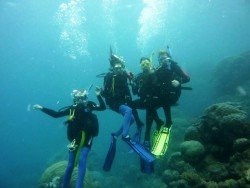
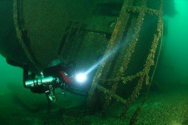
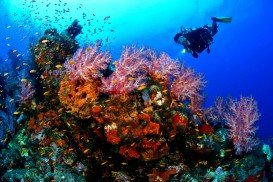
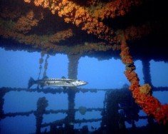
St. Thomas is home to a wide collection of spectacular wreck dive sites. With an amazing array of coral reefs, a variety of fish species and warm waters, this tropical destination attracts divers and snorkelers from all over the world. Just a short boat ride from Charlotte Amalie harbor, the Navy Barges is a wonderful wreck site for every diving enthusiast.
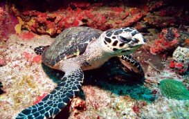
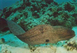
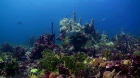
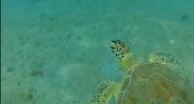
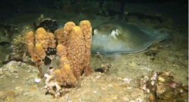
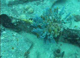
After World War II, the navy sunk the two barges, which lie parallel to each other in 12.2 m/40 ft depth of water. The wreck site is the ideal habitat for a selection of colorful corals and tropical fish, including parrot fish, big angelfish, nurse sharks, octopus, stingray, turtles and feather dusters. Keep in mind that it is also a great night dive spot. The average water temperature varies from 75°F/24°C in winter to 80°F/27°C in summer and the visibility ranges from 10 m/32.8 ft to 30 m/98.4 ft.
The Navy Barges welcomes both the beginner and experienced diver. Finally, you should book your dive in advance, as access to the dive site is only by boat. Note: be careful of boat traffic.
Kailua Kona is located in the North Kona District, Hawaii. It is a lively seaside town with sunny tropical weather all year long and lies at the bottom of the Hualalai Volcano.
Trinidad and Tobago is an island country that is situated just off the coast of northeastern Venezuela. Both Trinidad and Tobago islands surprise visitors with their unspoiled natural beauty that is not found in most of the other Caribbean islands. The climate here is classified as tropical with two seasons annually, the dry and rainy season and the winds are usually influenced by the northeast trade winds. The islands are known not only for their beautiful sandy beaches, but also for their carnivals.
Mombasa Marine Park & Reserve is located along the east coast of Kenya. The marine park covers an area of 6 mi/10 km (around 2,500 ac/10.12 km²) and the reserve a massive area of 124mi/200km square (around 49,400 ac/199.91 km²). Since it is located close to most of all the touristic areas, its beaches are one of the most visited and a great deal of activities take place at the same time.
Lake Michigan, the second largest of the Great Lakes of North America by volume and the third largest by surface area, is actually the only one located entirely within the United States. With its basin conjoining with that of Lake Huron to the east and having the same surface elevation, Lake Michigan and Lake Huron are technically a single lake. The large size of the Lakes and the fact that they are prone to sudden and harsh storms increases the risk of water travel and has led hundreds of ships to their end.
Ponta Do Ouro is the southern most village in Mozambique and is a popular holiday destination. It lies on the Mozambique Channel, southern of Maputo and just northern of the border with South Africa. Ponta Do Ouro boasts pristine beaches and is well known for its long stretches of white beaches. There are no tarred roads, therefore it is only accessible by 4x4 vehicles.
Perth is the capital city of Western Australia, located on the Swan River. The climate here is classified as Mediterranean, with hot and dry summers and cool and wet winters. Immerse yourself in the unique combination of stunning natural surroundings, beautiful beaches with clear waters, greenery park-lands and outstanding city architecture that attract visitors all year long.
The Virgin Islands of the United States, or the U.S. Virgin Islands lie in the Caribbean Sea, east of Puerto Rico. This group of islands consist of the main islands of Saint Thomas, which is home to the capital city of the U.S. Virgin Islands, Saint John, Saint Croix, Water Island and other surrounding minor islands.The climate here is classified as tropical savanna climate, mostly affected by moderate trade winds.