![La Vaca (Cow Cave), Medes Islands](https://www.xtremespots.com/wp-content/uploads/2014/09/Scuba-Diving-at-La-Vaca-273x153.jpg)
La Vaca (Cow Cave), Medes Islands
The Illes Medes (in Catalan) or Ilsas Medas (in Spanish) is a wonderful small group of seven islets in the northwest Mediterranean Sea. They are situated east of the coastal town of L'Estartit.
Home > WATER SPORTS > Scuba Diving > Cartanser Senior, Saint Thomas
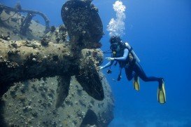
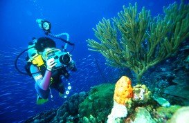
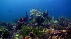
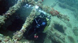
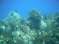
St. Thomas is well-known as the mecca for wreck enthusiasts, as it boasts many spectacular wreck dive sites. With a great selection of coral reefs and a wide variety of fish species, this tropical destination attracts divers at any time of the year. The Cartanser Senior or the Cartanza Senora is one of the most popular wreck dive sites on the island and it is visited by snorkelers and divers, due to its well-protected location.
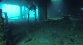
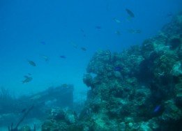
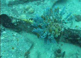
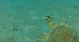
The spot is situated on the west side of Buck Island, just half an hour boat ride from Charlotte Amalie harbor. The Cartanser Senior was a freighter that was used to transport goods during World War II. It now lies in 45 ft/13.7 m depth of water and provides shelter to a wide variety of marine life, including ells, sharks, sergeant majors, parrot fish, southern stingrays, barracuda and turtles.
The ship is split into three sections. The mid section, the largest one, has the remains of the engine room. The wreck attracts divers of all experience levels and many dive boats visit the location daily. Note that the average water temperature varies from 75°F/24°C in winter to 80°F/27°C in summer and the visibility ranges from 10 m/32.8 ft to 30 m/98.4 ft. Finally, you should book your dive in advance, as access to the dive site is only by boat.
Visit Cartanser Senior as soon as possible and enjoy the best wreck dive ever!!!
The Illes Medes (in Catalan) or Ilsas Medas (in Spanish) is a wonderful small group of seven islets in the northwest Mediterranean Sea. They are situated east of the coastal town of L'Estartit.
Cade's Reef is situated at the south-west side of Antigua. Antigua is one of the two main islands of the country of Antigua and Barbuda in the West Indies. They all belong to Leeward Islands, on the north-east of Caribbean sea and on the west of Atlantic Ocean.
Victoria is the second-smallest state of Australia. It borders with New South Wales to the north and Tasman Sea to the east. The unique combination of spectacular coastline, pristine beaches, numerous national parks, dense forests and mountains attract visitors all year long and offer a plethora of activities to sport lovers.
The Bazaruto Archipelago is a group of six dune islands in Mozambique, namely Bazaruto, Benguera, Magaruque, Banque, Santa Carolina and Shell. The island complex is situated at 750 km/466 mi from Maputo. Known as the "Pearl of the Indian Ocean", the Archipelago is an island resort that hosts a protected and abundant marine life. The climate here is characterized by wet and dry seasons.
Pemba is a port town in Mozambique and the capital of the Cabo Delgado Province. It lies on a peninsula in Pemba Bay, which is the third-largest natural bay in the world. It is a prime destination for water sports and diving enthusiasts as the corals reef lies close to the shore. Climate here is tropical humid with average temperatures between 22-32°C/71.6-89.6°F.
Saona Island is a tropical island that is situated on the southeast tip of the Dominican Republic and is also part of East National Park. It is considered by many to be the earthly paradise. In fact, it is a very popular destination for tourists from all over the world. The island is not accessible by car or airplane, but this is not a problem, as many organised excursions are daily on offer.
The Virgin Islands of the United States, or the U.S. Virgin Islands lie in the Caribbean Sea, east of Puerto Rico. This group of islands consist of the main islands of Saint Thomas, which is home to the capital city of the U.S. Virgin Islands, Saint John, Saint Croix, Water Island and other surrounding minor islands.The climate here is classified as tropical savanna climate, mostly affected by moderate trade winds.