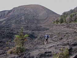
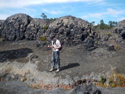
Volcano National park is located at 30 mi/48 km in the southwest of Hilo Town in Hawaii. The park was established in 1916 and is a combination of unique ecosystems and diverse environments that range from the sea to the summit of the world's biggest volcano, Mauna Loa, as well as Kilauea which is the world's most active volcano.
The park is an international World Heritage site and provides the visitors with several exciting hiking opportunities. Pu’u Loa Petroglyph’s Trail is 2 mi/3.2 km long, easy, around two hours round trip walk and starts at the Puu Loa parking, on Chains of Craters road.
Hiking there is a very interesting experience because you walk through the fascinating ancient history of Hawaii, the Pu’u Loa Petroglyphs. It is a historic site where you can admire the volcanic rock carvings, that represent a variety of ancient ideas, such as canoes, sails, human figures and more. The trail is very well marked but visitors should be careful of the unstable volcanic terrain and not to damage the petroglyph’s since they are very fragile.
Hikers should wear hiking boots, take water and snacks, sunglasses, sunscreen and a hat because the sun can be very intense. Due to the unstable terrain conditions, it is recommended, before choosing Pu’u Loa Petroglyphs Trail, to consult the Volcano National Park website for any park alerts that might prevent you from following this route.