Scuba Diving in Shallow Malongane Reef, Ponta Do Ouro,
Maputo Mozambique
Depths:
13-17m/42-55ft
Water Temperatures:
20-26°C / 68-78.8°F
Ponta Do Ouro is the southern most village in Mozambique and is a popular holiday destination. It lies on the Mozambique Channel, southern of Maputo and just northern of the border with South Africa. Ponta Do Ouro boasts pristine beaches and is well known for its long stretches of white beaches. There are no tarred roads, therefore it is only accessible by 4x4 vehicles.
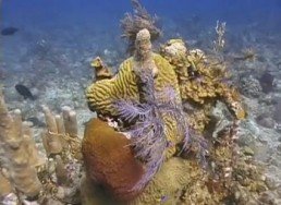
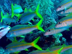
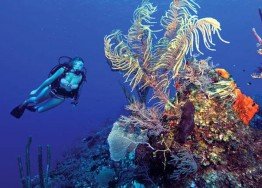
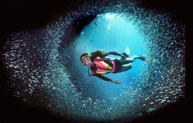
Shallow Malongane is a flat reef characterized by immaculate hard and soft corals. The spot has a vast area, covered by Stag Horn coral and stretches at about 3 km/1.9 mi into the Malongane Bay with sand patches along the reef edges.
It begins on the in-shore side at 16 m/52 ft making its way up to 13 m/42 ft then fades into the sand at 17 m/55 ft on the seaward side. In general, the dive depths range between 13-17 m/42-55 ft and due to its shallow depths and nearness to the beach, it is home to juvenile and game fish alike.
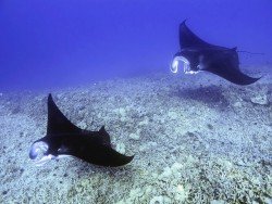
Some of the fish species to be seen here include the pickhandle barracuda and the eagle rays.
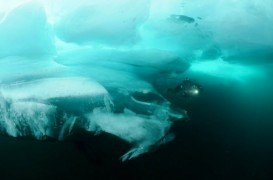
Lake Baikal is a rift lake, situated in the south of the region of Siberia, between the Republic of Buryatiya to the southeast and the Irkutsk Oblast to the northwest.
The Turks and Caicos Islands lie in the Lucayan Archipelago and are a British Overseas Territory consisting of eight islands: West Caicos, Providenciales, East Caicos, South Caicos, North and Middle Caicos, Grand Turk and Saly Cay. Only East and West Caicos are uninhabited. Apart from a superb tourist destination, they are also well-known as an offshore financial center. The climate of the islands is classified as marine tropical, providing relatively consistent temperatures throughout the year.
The Turks and Caicos Islands lie in the Lucayan Archipelago and are a British Overseas Territory consisting of eight islands: West Caicos, Providenciales, East Caicos, South Caicos, North and Middle Caicos, Grand Turk and Saly Cay. Only East and West Caicos are uninhabited. Apart from a superb tourist destination, they are also well-known as an offshore financial center. The climate of the islands is classified as marine tropical, providing relatively consistent temperatures throughout the year.
Inhambane is a city in the southern Mozambique, lying on the Inhambane Bay at 470 km/292 mi north-east of Maputo. Known as Terra De Boa Gente (Land of Good People), it is one of the oldest and prettiest settlements in Mozambique. The landscape surrounding Inhambane is dominated by vast coconut palms where an architectural atmosphere, rich in diverse history dominated the spot's character.
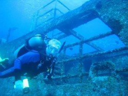
Bare Island is a small island, at about 16 km/9 mi in the south-east of Sydney's CBD (Central Business District). Bare Island is on the north side of Botany Bay and it is connected with a wooden bridge to the suburb of La Perouse. It is famous not only from the movie Mission Impossible II, but also from the number of dives that offers in the one site.
Ponta Do Ouro is the southernmost village in Mozambique and is a popular holiday destination. It lies on the Mozambique Channel, southern of Maputo and just northern of the borders with South Africa. Ponta Do Ouro boasts pristine beaches and is well known for its long stretches of white beaches. There are no tarred roads, therefore it is only accessible by 4x4 vehicles.
Ponta Do Ouro is the southern most village in Mozambique and is a popular holiday destination. It lies on the Mozambique Channel, southern of Maputo and just northern of the border with South Africa. Ponta Do Ouro boasts pristine beaches and is well known for its long stretches of white beaches. There are no tarred roads, therefore it is only accessible by 4x4 vehicles.
Ponta Do Ouro is the southernmost village in Mozambique and is a popular holiday destination. It lies on the Mozambique Channel, southern of Maputo and just northern of the border with South Africa. Ponta Do Ouro boasts pristine beaches and is well known for its long stretches of white beaches. There are no tarred roads, therefore it is only accessible by 4x4 vehicles.
Ponta Do Ouro is the southernmost village in Mozambique and is a popular holiday destination. It lies on the Mozambique Channel, southern of Maputo and just northern of the border with South Africa. Ponta Do Ouro boasts pristine beaches and is well known for its long stretches of white beaches. There are no tarred roads, therefore it is only accessible by 4x4 vehicles.
Ponta Do Ouro is the southern most village in Mozambique and is a popular holiday destination. It lies on the Mozambique Channel, southern of Maputo and just northern of the border with South Africa. Ponta Do Ouro boasts pristine beaches and is well known for its long stretches of white beaches. There are no tarred roads, therefore it is only accessible by 4x4 vehicles.
Ponta Do Ouro is the southern most village in Mozambique and is a popular holiday destination. It lies on the Mozambique Channel, southern of Maputo and just northern of the border with South Africa. Ponta Do Ouro boasts pristine beaches and is well known for its long stretches of white beaches. There are no tarred roads, therefore it is only accessible by 4x4 vehicles.
Ponta Do Ouro is the southern most village in Mozambique and is a popular holiday destination. It lies on the Mozambique Channel, southern of Maputo and just northern of the border with South Africa. Ponta Do Ouro boasts pristine beaches and is well known for its long stretches of white beaches. There are no tarred roads, therefore it is only accessible by 4x4 vehicles.
Ponta Do Ouro is the southernmost village in Mozambique and is a popular holiday destination. It lies on the Mozambique Channel, southern of Maputo and just northern of the border with South Africa. Ponta Do Ouro boasts pristine beaches and is well known for its long stretches of white beaches. There are no tarred roads, therefore it is only accessible by 4x4 vehicles.