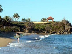
Lecount Hollow Beach, Cape Cod
Lecount Hollow is another exposed beach of Massachusetts, which means that there is good wind for surfers all year round.
Home > BOARD SPORTS > Surfing > Enderts Beach, Crescent City
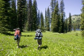
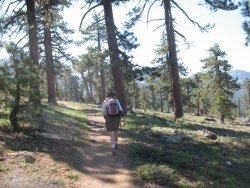
The beach is not for swimming. This is a wild beach that imposes a short 1 mi/1.6 km walk. The beach has an arch, rocks and tide pools teeming with life. If visitors choose to walk on the beach, they should definitely discover and explore the Enderts beach trail, which is surrounded by wildflowers, ferns, trees, a creek and a forest down the beach.
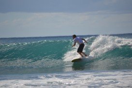
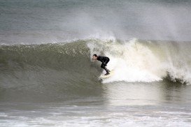
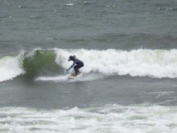
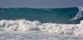
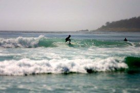
At the end of the beach, there are some rock pools that are filed with starfish and giant green anemone. Besides that, the beach is popular to surfers. The wave quality is normal and it is ideal for all kind of surfers, experienced or not. Type of the wave is beach – break and the direction is both left and right.
The bottom of the sea has flat rocks with sand. Power of the wave is ordinary and fun, and the normal length of the wave is short, about 164 ft/50 m. In good days, the length of the wave is normally 164 to 492 ft/50 to 150 m. Good swell direction is northwest and southwest and the good wind direction is east.
Swell size starts at less than 1 m/3 ft and holds up to 2 m+/6 ft+. Best tide movement is mid tide. Surfers should watch out for rips and underflow.
Lecount Hollow is another exposed beach of Massachusetts, which means that there is good wind for surfers all year round.
County Cork is situated in the South-West Region of Ireland and it is the largest of all Irish counties. The climate here, like the rest of Ireland, is classified as a maritime climate, usually with cool summers, mild winters and abundant rainfall. Cork enchants visitors with its beautiful landscapes, historic towns and magnificent coastline. In addition, it provides with a number of sporting and leisure activities to perform and remember forever.
Honokaa town is located in the Hamakua Coast, at 64 km/40 mi in the north of Hilo. The area is a historic district on Big Island, Hawaii because the town's economy was once based on sugar production from the Hamakua Sugar Company, until 1994.
Puerto Rico is situated in the northeastern Caribbean and consists of an archipelago that includes the main island of Puerto Rico and a number of smaller islands. The climate here is classified as tropical marine climate, with an average temperature of 82.4°F/ 28°C, throughout the year. Although it is a small island, the smallest island of the Greater Antilles, Puerto Rico provides superb natural surroundings, countless adventure experiences and many places of historical interest.
Trinidad and Tobago is an island country that is situated just off the coast of northeastern Venezuela. Both Trinidad and Tobago islands surprise visitors with their unspoiled natural beauty that is not found in most of the other Caribbean islands. The climate here is classified as tropical with two seasons annually, the dry and rainy season and the winds are usually influenced by the northeast trade winds. The islands are known not only for their beautiful sandy beaches, but also for their carnivals. Trinidad boasts one of the largest carnivals in the world that promises to get you in the festive spirit.
Tasmania is Australian island state, located at 240 km/150 mi in southeast of Australia's mainland. The island of Tasmania is an ideal destination, as it offers a diverse vegetation with many unique flora and fauna species, dense forests, pristine beaches and ideal weather conditions to perform your favorite extreme activity.
Mount Shasta is located in northern California, east of Interstate 5 along SR89, between Mount Shasta city and McCloud city, California, USA.
Big Lagoon is located at 7 mi/11.3 km north of Trinidad, Humboldt County, California, USA.
Crescent City Harbor is located in the south end of Crescent City, on Anchor Way of Highway 101, Del Norte County, California, USA.
Pelican State Beach is located at 21 mi/33.8 km north of Crescent City, south of Oregon border, Del Norte County, California, USA.
Mount Shasta is located in northern California, east of Interstate 5 along SR89, between Mount Shasta city and McCloud city, California, USA.
Lake Earl is located in Talawa Dunes State Park, north of Crescent City, Del Norte County, California, USA.
Crescent South Beach is located near Crescent City, Del Norte County, California, USA.