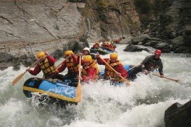
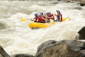
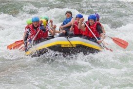
Rafting in Ash River, Clarens,
Free State South Africa
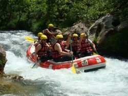
Grade:
2-4
Distance:
17km/10.5mi
The Free State is situated on the flat boundless plains in the heart of South Africa. Known locally as the "breadbasket" of South Africa, it is an agricultural city and most of its land lies at 1000 m/3281 ft above sea level. It is the land of rugby, sunny skies and characterized by a continental climate, with warm to hot summers and cool to cold winters.
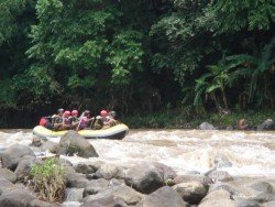
The Ash River, just outside Clarens, offers the best white water rafting conditions in South Africa thanks to the Lesotho Highlands Water Project which has a great deal of influential effect. Experience the splash and feel the adrenalin rush of a life time!! White water rafting here is an all year round adventure and boast 17 rapids.
Graded between 2-4, it covers a distance of 17 km/10.5 mi and is a guided tour with spectacular scenic vegetation and magnificent bird-life. Age limit here is from 6 to 106 years-old and the minimum pax is 2.
Queenstown is considered by many as the capital of extreme sports. It is situated in Otago region, in the South Island, New Zealand, and is surrounded by Lake Wakatipu and the awe-inspiring Southern Alps.
The plateau of Folois nestles at the southwest foot of Mount Erymanthus, in Hleia. Its name derived from mythology and the king of the Centaurs, Follo, friend of Hercules. Folois forest, with the unrivaled natural beauty, is one of the largest oak forests in Europe.
Java is the 5th largest island in Indonesia and the world's most populous as well. It acts as Indonesia's center of cultural and economic activity. Java is divided into four provinces, West Java, East Java, Central Java and Banted plus two additional special regions, Jakarta and Yogyakarta. Java is almost entirely of volcanic origin and lies between Sumatra to the west and Bali to the east.
Berthoud Pass is located between Idaho Springs and Winter Park and is one of the closest areas in Denver for whitewater rafting. It belongs to Boulder County and is just an hour away.
Wenatchee is the largest city of Chelan County, located in North Central Washington and lies on the west side of the Columbia River. The city is also known as the Apple Capital of the world, due to the valley's many apple cultivations.
Bad Tölz is located at 52 km/32 mi in the south of Munich in Bavaria and it is the administrative center of the district of Bad Tölz-Wolfratshausen. Blomberg – Bad Tölz ski resort is situated in the vicinity of Bad Tölz. On the backdrop of the Bavarian Alps, you will experience this cruise on the romantic Isar river, an ideal and easy introduction to white water rafting.
The Free State is situated on the flat boundless plains in the heart of South Africa. Known locally as the "breadbasket" of South Africa, it is the agricultural city and most of its land is at 1000 m/3281 ft above sea level. It is the land of rugby, sunny skies and characterized by a continental climate, with warm to hot summers and cool to cold winters.
The Free State is situated on the flat boundless plains in the heart of South Africa. Known locally as the "breadbasket" of South Africa, it is an agricultural city and most of its land lies at 1000 m/3281 ft above sea level. It is the land of rugby, sunny skies and characterized by a continental climate, with warm to hot summers and cool to cold winters.
The Free State is situated on the flat boundless plains in the heart of South Africa. Known locally as the "breadbasket" of South Africa, it is the agricultural city and most of its land is at 1000 m/3281 ft above sea level. It is the land of rugby, sunny skies and characterized by a continental climate, with warm to hot summers and cool to cold winters.