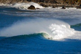
Salmon Hole, Yorke Peninsula
Salmon Hole is another great surfing spot in Yorke Peninsula, close to Innes National Park and the Marion Bay. Marion Bay is the doorstep to some of the best beaches in Australia that host a rich maritime history.
Home Ā >Ā BOARD SPORTS Ā >Ā Surfing Ā >Ā Mckenzies, Tamarama
This spot is an exposed beach break that usually offers good waves. Offshore winds blow from the north and the ideal swell direction is from the south. Surfers can explore the waves with swell sizes from 3 ft/1 m to 8 ft/2.5 m. The best tide movement is rising and falling tide.
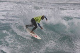
Mckenzies is appropriate for all levels of surfers. In summer the wind blows offshore at 6%, in autumn the wind blows at 18%, in winter at 34% and in spring at 16%. Last but not least, visitors can enjoy the magnificent view of the sea in one of the many cafes and restaurants that lie on the streets around the spot. Watch out for sharks, rocks and rips. Note: it gets crowded when it works.
Salmon Hole is another great surfing spot in Yorke Peninsula, close to Innes National Park and the Marion Bay. Marion Bay is the doorstep to some of the best beaches in Australia that host a rich maritime history.
Klamath River is a beautiful beach near Klamath, Del Norte County, California, USA.
West Sussex is located in the south of England. The climate here is classified, like in the rest of the British Isles, as oceanic climate with chilly winters and warm summers. West Sussex offers a plethora of recreational activities and sports for visitors and locals alike.
Located on Thatcher Road, Rte 127A, Good harbor beach is a relatively small, sandy beach in Gloucester, suitable for all levels of experience.
Victoria is the second-smallest state of Australia. It faces New South Wales to the north and Tasman Sea to the east. The unique combination of spectacular coastline, pristine beaches, numerous national parks, dense forests and mountains attract visitors all year long and offer a plethora of activities to extreme sports lovers.
Beach Haven is a borough in Ocean County, New Jersey, United States, which is located on Long Beach Island ( LBI ) and borders the Atlantic Ocean. Beach Haven, known on LBI as the " Queen City ", was ranked as the ninth-best beach in New Jersey.
Balmoral is an urban locality in the suburb of Mosman, at about 8 km/5 mi in the north-east of Sydney's CBD. Balmoral beach lies on the northern side of Sydney Harbor and provides with a number of local facilities, restaurants and cafes. It also offers a plethora of activities, such as surfing, sailing, diving and snorkeling.
Collaroy is a suburb in the northern Sydney, at about 22km/13mi in the north-east of Sydney's CBD (central business district). It is a small village, built in a stunning setting with some good cafes, bars and restaurants.
Balmoral is an urban locality in the suburb of Mosman, at about 8 km/5 mi in the north-east of Sydney's CBD (Central Business District).
Manly is a suburb of northern Sydney. On the harbor side of Manly, divers will discover an excellent dive site.
Mona Vale is a suburb in northern Sydney, at about 28 km/17 mi in the north of Sydney's CBD (Central Business District). Mona Vale beach streches at about 1 km/1093.6 yd in between the broad rock platform that divides it from the Basin on the north side and the Warriewood beach, on the south side. This spot provides you with good facilities and a picnic area.
Bondi beach is the widest and most famous beach in the Sydney region. It is located in the suburb of Bondi, at just 7 km/4 mi from the center of Sydney. This spot offers a variety of activities to visitors seeking for adventure, such as rock climbing.
Cronulla is a beach-side suburb in southern Sydney, at about 26 km/16 mi in the south of Sydney's CBD (Central Business District). Cronulla lies on a peninsula, between Botany Bay to the north and Port Hacking to the south. Cronulla is a popular tourist location and attracts many beach enthusiasts.
Port Hacking is located in southern Sydney, at about 30 km/19 mi south of Sydney's CBD (Central Business District). The area to the north of Port Hacking is more developed than the area to the south, which forms the northern boundary of the Royal National Park. It is south of Cronulla and northeast of Bundeena.