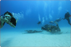
Scuba Diving in Usukan Bay, Kota Kinabalu,
Sabah Malaysia
Dive Depths:
26-40m/85-131ft
Dive Type :
Wreck Dive
Famous due to its proximity with tropical islands, lush forests and Mount Kinabalu, Kota Kinabalu is the capital of the state of Sabah located in Borneo. It is located on the west coast of Sabah within the West coast Division. Formerly known as Jesselton, it enjoys a tropical rainforest climate and lies by the coast, overlooking the South China Sea and bordered by the Crocker range which is home to Mount Kinabalu.
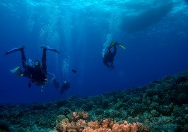
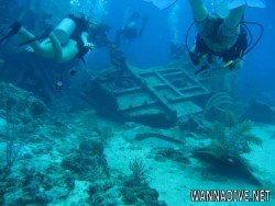
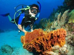
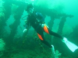
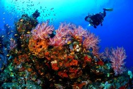
Usukan Bay offers a quality wreck diving experience. The bay comprises of 3 World War II Japanese wrecks which were all sunk on the same day in October 14th, 1944. These wrecks brought about 3 awesome wreck dive spots namely the “Usukan Wreck”, “The Rice-Bowl Wreck” and the “Upside-down Wreck”. Diving at these sites make a memorable experience and accommodates the advanced open water and technical diver with minimum qualifications and all dives are no-decompression.
All these wreck dives are located at 26-40 m/85-131 ft in depth below the sea level and have small to medium currents. This constitutes one more reason why experienced divers can attempt scuba diving here. The wrecks are characterized by both stunning hard and soft corals with abundant marine life. The minimum pax is 4 per dive and divers are advised to use Nitrox for underwater time extension.
Kailua Kona is located in the North Kona District, Hawaii. It is a lively seaside town with sunny tropical weather all year long and lies at the bottom of the Hualalai Volcano.
Perth is the capital city of Western Australia, located on the Swan River. The climate here is classified as Mediterranean, with hot and dry summers and cool and wet winters. Immerse yourself in the unique combination of stunning natural surroundings, beautiful beaches with clear waters, greenery park-lands and outstanding city architecture that attract visitors all year long.
The Cayman Islands are a British Overseas Territory, situated northwest of Jamaica and south of Cuba, in the western Caribbean Sea. The territory consists of three islands, the Grand Cayman, the Cayman Brac and the Little Cayman. George Town is the capital, located on Grand Cayman, the largest of the three islands. All of the islands enjoy a tropical marine climate, with hot summers and dry, cool winters.
Victoria is the second-smallest state of Australia. It borders with New South Wales to the north and Tasman Sea to the east. The unique combination of spectacular coastline, pristine beaches, numerous national parks, dense forests and mountains attract visitors all year long and offer a plethora of activities to sport lovers.
The wall is located at the north of Sydney Harbour, at the south-eastern end of the Long Reef. This site is considered to be the best reef dive site on the north shore.
Famous for its proximity with the tropical islands, lush forests and Mount Kinabalu, Kota Kinabalu is the capital of the state of Sabah located in Borneo. It is located on the west coast of Sabah within the West coast Division. Formerly known as Jesselton, it enjoys a tropical rainforest climate and lies by the coast overlooking the South China Sea and bordered by the Crocker range which is home to Mount Kinabalu.
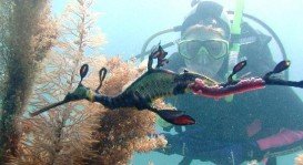
Pulau Tiga is located at 48 km/30 mi in the south of Kota Kinabalu and became well known due to the "Survivor" series, hosting the setting of "Survivor Borneo", the first American season of the show. Scuba diving in Pulau Tiga is open to all levels of divers and is a prime location for macro lovers and underwater photography. The spot is believed to have been formed by the eruption of several mud volcanoes and is at 100 m/328 ft above sea level.
Famous due to its proximity with tropical islands, lush forests and Mount Kinabalu, Kota Kinabalu is the capital of the state of Sabah located in Borneo. It is located on the west coast of Sabah within the West coast Division. Formerly known as Jesselton, it enjoys a tropical rainforest climate and lies by the coast, overlooking the South China Sea and bordered by the Crocker range which is home to Mount Kinabalu.
Pulau Tiga is located at 48 km/29.9 mi in the south of Kota Kinabalu and became well known due to the "Survivor" series, hosting the setting of "Survivor Borneo", the first American season of the show. Scuba diving in Pulau Tiga is open to all levels of divers and is a prime location for macro lovers and underwater photography. The spot is believed to have been formed by the eruption of several mud volcanoes and is at 100 m/328 ft above sea level.
Famous for its proximity with the tropical islands, lush forests and Mount Kinabalu, Kota Kinabalu is the capital of the state of Sabah located in Borneo. It is located on the west coast of Sabah within the West coast Division. Formerly known as Jesselton, it enjoys a tropical rainforest climate and lies by the coast overlooking the South China Sea and bordered by the Crocker range which is home to Mount Kinabalu.
Famous for its proximity with tropical islands, lush forests and Mount Kinabalu, Kota Kinabalu is the capital of the state of Sabah located in Borneo. It is located on the west coast of Sabah within the West coast Division. Formerly known as Jesselton, it enjoys a tropical rainforest climate and lies by the coast, overlooking at the South China Sea and bordered by the Crocker range which is home to Mount Kinabalu.
Pulau Tiga is located at 48 km/30 mi in the south of Kota Kinabalu and became well known due to the "Survivor" series, hosting the setting of "Survivor Borneo", the first American season of the show. Scuba diving in Pulau Tiga is open to all levels of divers and is a prime location for macro lovers and underwater photography. The spot is believed to have been formed by the eruption of several mud volcanoes and is at 100 m/328 ft above sea level.
Famous due to its proximity with tropical islands, lush forests and Mount Kinabalu, Kota Kinabalu is the capital of the state of Sabah located in Borneo. It is located on the west coast of Sabah within the West coast Division. Formerly known as Jesselton, it enjoys a tropical rainforest climate and lies by the coast, overlooking at the South China Sea and bordered by the Crocker range which is home to Mount Kinabalu.
Famous for its proximity with the tropical islands, lush forests and Mount Kinabalu, Kota Kinabalu is the capital of the state of Sabah located in Borneo. It is located on the west coast of Sabah within the West coast Division. Formerly known as Jesselton, it enjoys a tropical rainforest climate and lies by the coast overlooking the South China Sea and bordered by the Crocker range which is home to Mount Kinabalu.