Lyons Reservoir, Sonora
Sonora Pass is located near Pinecrest, Tuolumne County, California, USA. It is off of Highway about 60 mi/96.5 km east of Sonora.
Home  > MOUNTAIN SPORTS  > Extreme Hiking / Hiking  > Beezley Hills Preserve Route, Wenatchee
Beezley Hills Preserve is an area protected by the Nature Conservatory. The trail is 3 mi/4.8 km long, (loop hike), about three hours hike, with minimal elevation.
The preserve protects a wide variety of wildlife and plants. If you visit this trail during spring, you will come across a unique flower display with an abundance of hedgehog cactuses, blooming with bright pink flowers. Once you cross the gate, walk towards the east side and enter a wild flower garden.
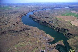
After you leave the ridge area, the scenery changes into a more fertile ground with different flora species. The best time to hike this trail is from April through May. Beezly Hills Preserve is an exciting hike for nature lovers and offers beautiful views of the broad lands of the Columbia Basin.
Sonora Pass is located near Pinecrest, Tuolumne County, California, USA. It is off of Highway about 60 mi/96.5 km east of Sonora.
Bear Valley is a ski area located near Angels Camp, on highway 4, between Lake Tahoe and Yosemite, approximately 3 hours southeast of Sacramento, California, USA.
Sonora Pass is located near Pinecrest, Tuolumne County, California, USA. It is off of Highway about 60 mi/96.5 km east of Sonora.
Mount Shasta is located in northern California, east of Interstate 5 along SR89, between Mount Shasta city and McCloud city, California, USA.
Torres del Paine is located in Southern Patagonia and is one of the numerous spectacular national parks in Chile. It was created in 1959 and UNESCO has listed the location as a Biosphere Reserve since 1978. This place is a wonder land for hikers from all over the world.
Wenatchee is the largest city of Chelan County, located in North Central Washington and lies on the west side of the Columbia River. The city is also known as the Apple Capital of the world, due to the valley's apple cultivations.
Dayton City is located in the Southeastern part of Washington State. It lies in a valley, at 1600 ft/487 m above sea level and is situated in-between two rivers, Patit Creek and Touchet River.
Wenatchee is the largest city of Chelan County, located in North Central Washington and lies on the west side of the Columbia River. The city is also known as the Apple Capital of the world, due to the valley's many apple cultivations.
Wenatchee is the largest city of Chelan County, located in North Central Washington and lies on the west side of the Columbia River. The city is also known as the Apple Capital of the world, due to the valley's apple cultivations.
Wenatchee is the largest city of Chelan County, located in North Central Washington and lies on the west side of the Columbia River. The city is also known as the Apple Capital of the world, due to the valley's many apple cultivations.
