
La Molina, Girona
Alp 2500 is a complex of ski resorts in La Cerdanya, Catalonia, in the Pyrenees mountains of northeastern Spain. It includes the two towns of La Molina and Masella, whose two respective ski areas united form Alp 2500.
Home > BOARD SPORTS > Cross Country Skiing > Dodge Ridge, Sonora
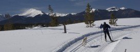
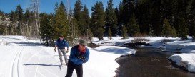
The resort is located in the Stanislaus National Forest. Around Sonora Pass, there are so many routes up and down the pass, making it a perfect and popular place for cross country skiing. There are 25.5 mi/41 km of cross country skiing trails in the Summit Ranger District, which are marked southwest of Pinecrest, mostly in the vicinity of Dodge Ridge.
Two trails with a total distance of 5 mi/8 km are rated as easy, nine trails (16 mi/25.75 km) as intermediate and three trails as most difficult. The trails are usually patrolled on weekends. You can purchase a map of the trails at the Summit Ranger Station, at the Pinecrest Y.
When developing a trail after a new snowfall, try to develop a two user trail, that will contain cross country set of ski tracks. Trailheads in the area are found at Gooseberry and Crabtree, on Forest road 4N35, near Dodge Ridge. The weather changes a lot and especially in winter, it can be unsafe, so you should better be informed about the weather conditions, before arriving to the spot.
There are two trailheads to the nordic trails. Crabtree, which is near the junction of Dodge Ridge Road and Dodge Ridge Loop and Gooseberry, which is further up the Dodge Ridge Loop.
Alp 2500 is a complex of ski resorts in La Cerdanya, Catalonia, in the Pyrenees mountains of northeastern Spain. It includes the two towns of La Molina and Masella, whose two respective ski areas united form Alp 2500.
Dombay is an urban locality situated in the Karachay-Cherkess Republic, in Russia. The administrative jurisdiction of the resort settlement is the town of republic significance of Karachayevsk. The locality is situated in the Teberda Nature Reserve (Teberdinskiy zapovednik) and is a popular tourist destination.
The National Park of Saint-Bruno is a provincial park of Quebec, that offers to its visitors a wide range of summer and winter activities and plenty of rest. Visiting this park, you make a priceless gift to yourself, as here you can find all you need for your best trip. What makes this place unique for ski activities is the fact that all trails are formed by 100% of snow-making and it is located just a few steps away from Montreal.
Mount Shasta is located in northern California, east of Interstate 5 along SR89, between Mount Shasta city and McCloud city, California, USA.
A notorious route for cross country skiing. Bennett Pass is located near the Tea Cup Lake, in Mt. Hood area.
Mont Rigaud is a municipality in southwestern Quebec, Canada. It is a small mountain with excellent snow conditions and natural beauty. Mont Rigaud is a tourist destination for those who want to get in touch with the snow environment and learn how to perform their favorite ski activity.
Yosemite National Park is located near Mariposa, California, USA.
Sonora Pass is located near Pinecrest, Tuolumne County, California, USA. It is off of Highway about 60 mi/96.5 km east of Sonora.
Mount Shasta is located in northern California, east of Interstate 5 along SR89, between Mount Shasta city and McCloud city, California, USA.
Bear Valley is a ski area located near Angels Camp, on highway 4, between Lake Tahoe and Yosemite, approximately 3 hours southeast of Sacramento, California, USA.
Mammoth Lakes is located near Mammoth Mountain, in California’s eastern Sierra about 100 mi/161 km south of Nevada State Line, 9 mi/14.5 km northwest of Mount Morrison, at an elevation of 7880 ft/2402 m, Mono County, California, USA.
Bear Valley is a ski area located near Angels Camp, on highway 4, between Lake Tahoe and Yosemite, approximately 3 hours southeast of Sacramento, California, USA.
Badger Pass Ski Area is a small ski area which is located in Yosemite National Park, near Mariposa, California, USA.
Mammoth Lakes is located near Mammoth Mountain, in California’s eastern Sierra about 100 mi/161 km south of Nevada State Line, 9 mi/14.5 km northwest of Mount Morrison, at an elevation of 7880 ft/2402 m, Mono County, California, USA.