Narrabeen Beach, Narrabeen
Narrabeen is a suburb in northern Sydney, at about 23 km/14 mi north-east of Sydney's CBD (Central Business District).
Home > BOARD SPORTS > Surfing > Carmel River State Beach, Monterey
It is a 1 mi/1.6 km long, breathtaking, public beach with a beautiful lagoon formed by the Carmel River. Carmel River State Beach merges with San Jose Creek State Beach (Monastery Beach). The park was established in 1953. In the lagoon immigrate a large number of migratory birds. Winter and fall are the best seasons for bird watching.
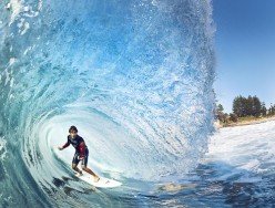
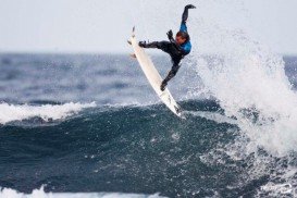
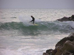
Carmel River State Beach at the section of Central Coast Birding Trail is believed to be one of the most dangerous places for swimming, because of the steep drop – off from shore creating turbulent waves that are incorrectly shown as calm sea and the strong currents. Surfing is a very popular sport in Carmel river state beach.
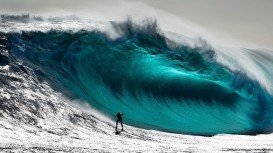
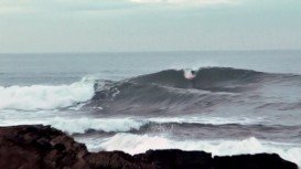
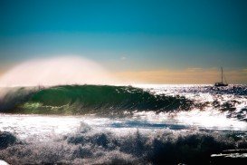
The wave quality is regional classic. Surfers should be pros or kamikaze. The type of the wave is sand – bar and the direction is both right and left. Rocks and sand are found at the bottom of the sea. Power of the waves is hollow, fast and powerful and their normal length is short (164 ft/50 m), being the same also on good days.
Good swell direction and good wind direction is northwest / west and swells size starts at 1 m – 1.5 m / 3 ft – 5 ft and holds up to 3 m+ / 10 ft+. Best tide position is mid tide and best tide movement is falling tide. Surfers should watch out for rips / undertow and rocks.
Narrabeen is a suburb in northern Sydney, at about 23 km/14 mi north-east of Sydney's CBD (Central Business District).
Cronulla is a beach-side suburb in southern Sydney, at about 26 km/16 mi in the south of Sydney's CBD (Central Business District). Cronulla lies on a peninsula, between Botany Bay on the north and Port Hacking on the south. Cronulla is a popular tourist location and attracts many beach enthusiasts.
At 54 km/33 mi in the north of Aberdeen city, there is a town called Broadsea Point bay. The bay starts from the town of Fraserburgh until the eastern side of Cairnbulg Point.
Mooloolaba is a popular tourist destination, located at 97 km/60 mi north of Brisbane, the capital state. Mooloolaba provides a port with its marinas, beautiful ocean beaches, a vast number of quality restaurants, stylish cafe and great bars.
Pennan is a small settlement, laid across Pennan beach. The area is windy from April to October and the spot is preferably chosen by surfers and wind surfers.
Peniche is a municipality and a seaside city, situated in formerly Estremadura Province, in Oeste Subregion. The municipality consists of 6 parishes and it is a popular surfing destination.
La Ventana is located on the south-eastern side of Baja California Sur, Mexican state. Baja California Sur is the second smallest Mexican state by population and is situated in northwestern Mexico. It is bordered to the west by the Pacific Ocean and to the east by the Gulf of California.
Sugar Bowl ski resort is a ski area in northern Placer County, near Norden, along Donner Pass of Sierra Nevada, at about 46 mi/74 km from Reno on Interstate 80, California, USA. The resort was opened on the 15th of December, 1939.
Mammoth Lakes is located near Mammoth Mountain, in California’s eastern Sierra about 100 mi/161 km south of Nevada State Line, 9 mi/14.5 km northwest of Mount Morrison, at an elevation of 7880 ft/2402 m, Mono County, California, USA.
Tamarack Lodge Resort is located in Mammoth Lakes, near Mammoth Mountain, in California’s eastern Sierra about 100 mi/161 km south of Nevada State line Mono County, California, USA.
Mammoth Lakes is located near Mammoth Mountain, in California’s eastern Sierra about 100 mi/161 km south of Nevada State Line, 9 mi/14.5 km northwest of Mount Morrison, at an elevation of 7880 ft/2402 m, Mono County, California, USA.
Soda Springs ski resort is located near Soda Springs, Nevada County, California, USA. Soda Springs ski resort is just off of Highway 80, near the Donner Summit.
Mammoth Lakes is located near Mammoth Mountain, in California’s eastern Sierra about 100 mi/161 km south of Nevada State Line, 9 mi/14.5 km northwest of Mount Morrison, at an elevation of 7880 ft/2402 m, Mono County, California, USA.
Mammoth Mountain is located in California’s eastern Sierra, at 100 mi/161 km south of Nevada State line and 50 minutes from the Eastern Gate of Yosemite National Park.